ERATOSTHENES Centre of Excellence: Final report on the devastating wildfire
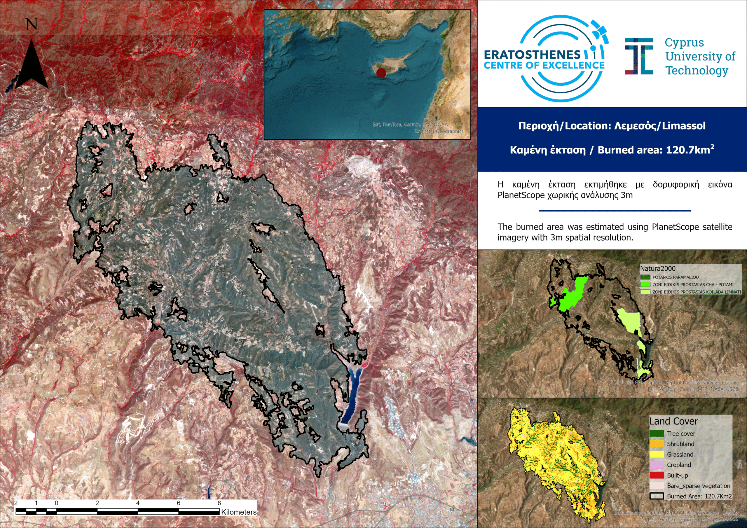
According to the latest analysis by the ERATOSTHENES Centre of Excellence, the devastating wildfire that broke out in the Limassol district on 23 July 2025 is estimated to have burned a total of 120.7 km². Taking into account that the total area of Cyprus is 9,251 km², the burned area corresponds to approximately 1.3% of the island’s surface, a particularly significant percentage considering that it resulted from a single wildfire. This loss affects not only the region’s biodiversity and natural heritage but also local communities and ecosystems, which will require decades to recover.
The estimate is based on high‑resolution (3 m) satellite data from the PlanetScope constellation, acquired on 26 July 2025 at 09:00 (UTC).
Also, according to data from the WorldCover program of the European Space Agency (ESA), of the total burned area:
-approximately 51% consists of grasslands,
-31% shrubland,
-15.5% forested areas,
-while 1.1% corresponds to residential areas.
In addition, about 21% of the burned area falls within the Natura 2000 network, affecting important protected sites such as the Paramaliou River, the Cha‑Potami Special Protection Area, and the Limmati Valley Special Protection Area.
…………………………………………………………………………………………………………………………………………………..
ΕΡΑΤΟΣΘΕΝΗΣ: Τελική εκτίμηση από την καταστροφική πυρκαγιά
Σύμφωνα με τη νέα ανάλυση του Κέντρου Αριστείας ΕΡΑΤΟΣΘΕΝΗΣ, η καταστροφική πυρκαγιά που εκδηλώθηκε στην επαρχία Λεμεσού στις 23/7/2025 εκτιμάται ότι έχει κατακάψει συνολικά 120,7 km². Λαμβάνοντας υπόψη ότι η συνολική έκταση της Κύπρου ανέρχεται σε 9.251 km², η καμένη περιοχή αντιστοιχεί περίπου στο 1,3% της έκτασης του νησιού, ποσοστό ιδιαίτερα σημαντικό αν αναλογιστεί κανείς ότι συγκεντρώνεται σε μια μόνο πυρκαγιά. Η απώλεια αυτή επηρεάζει όχι μόνο τη βιοποικιλότητα και τη φυσική κληρονομιά της περιοχής, αλλά και τις τοπικές κοινότητες και τα οικοσυστήματα που χρειάζονται δεκαετίες για να ανακάμψουν.
Η εκτίμηση προέρχεται από δορυφορικά δεδομένα υψηλής ανάλυσης (3 μ.) του αστερισμού PlanetScope, τα οποία λήφθηκαν στις 26/7/2025 στις 09:00 (UTC).
Με βάση τα δεδομένα του προγράμματος WorldCover του Ευρωπαϊκού Οργανισμού Διαστήματος (ESA), από τη συνολική καμένη έκταση:
-περίπου 51% αφορά χορτολιβαδικές εκτάσεις,
-31% σκληροφυλλική βλάστηση,
-15,5% δεντρώδη βλάστηση,
-ενώ 1,1% αντιστοιχεί σε οικιστικές περιοχές.
Επιπλέον, περίπου 21% της καμένης έκτασης εμπίπτει στο δίκτυο Natura 2000, επηρεάζοντας σημαντικές προστατευόμενες περιοχές, όπως τον Ποταμό Παραμαλιού, τη Ζώνη Ειδικής Προστασίας Χα‑Ποτάμι και τη Ζώνη Ειδικής Προστασίας Κοιλάδα του Λιμνάτη.
